|
|
|||||||||||||||||
| Point ID: 9648 | Downloads | Plots | Site Data | Code: 05107000 |
|
|
|||||||||||||||||
| Download | |
|---|---|
| Site Descriptor Information | Site Time Series Data |
| Link to all available data | |
| View: | Time Series | All |
| Units: | m3/s |
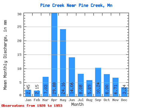
| Statistic | Jan | Feb | Mar | Apr | May | Jun | Jul | Aug | Sep | Oct | Nov | Dec | Annual |
|---|---|---|---|---|---|---|---|---|---|---|---|---|---|
| Mean | 2.46 | 2.17 | 7.03 | 29.87 | 24.16 | 14.06 | 8.08 | 5.89 | 10.24 | 7.99 | 6.71 | 3.24 | 123.41 |
| Standard Deviation | 1.00 | 0.69 | 9.58 | 14.53 | 16.70 | 11.94 | 7.01 | 5.57 | 14.51 | 5.99 | 4.00 | 0.84 | 53.00 |
| Min | 0.39 | 0.72 | 0.79 | 7.08 | 6.99 | 5.39 | 1.76 | 0.39 | 1.42 | 2.37 | 2.31 | 1.38 | 43.24 |
| Max | 3.97 | 3.15 | 43.59 | 64.62 | 85.77 | 44.70 | 23.65 | 23.30 | 59.71 | 23.69 | 20.36 | 4.46 | 272.69 |
| Coefficient of Variation | 0.41 | 0.32 | 1.36 | 0.49 | 0.69 | 0.85 | 0.87 | 0.95 | 1.42 | 0.75 | 0.60 | 0.26 | 0.43 |
 Return to R-Arctic Net Home Page