|
|
|||||||||||||||||
| Point ID: 9647 | Downloads | Plots | Site Data | Code: 05123600 |
|
|
|||||||||||||||||
| Download | |
|---|---|
| Site Descriptor Information | Site Time Series Data |
| Link to all available data | |
| View: | Time Series | All |
| Units: | m3/s |
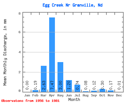
| Statistic | Jan | Feb | Mar | Apr | May | Jun | Jul | Aug | Sep | Oct | Nov | Dec | Annual |
|---|---|---|---|---|---|---|---|---|---|---|---|---|---|
| Mean | 0.00 | 0.09 | 1.26 | 3.59 | 1.44 | 0.57 | 0.36 | 0.04 | 0.06 | 0.14 | 0.08 | 0.01 | 7.82 |
| Standard Deviation | 0.00 | 0.47 | 3.34 | 5.74 | 2.64 | 1.02 | 0.84 | 0.07 | 0.15 | 0.34 | 0.21 | 0.03 | 9.10 |
| Min | 0.00 | 0.00 | 0.00 | 0.00 | 0.00 | 0.00 | 0.00 | 0.00 | 0.00 | 0.00 | 0.00 | 0.00 | 0.00 |
| Max | 0.01 | 2.36 | 15.52 | 23.46 | 9.85 | 3.56 | 4.12 | 0.23 | 0.60 | 1.19 | 0.90 | 0.10 | 26.62 |
| Coefficient of Variation | 5.00 | 5.00 | 2.64 | 1.60 | 1.83 | 1.77 | 2.33 | 1.65 | 2.68 | 2.37 | 2.65 | 3.02 | 1.16 |
 Return to R-Arctic Net Home Page