|
|
|||||||||||||||||
| Point ID: 9631 | Downloads | Plots | Site Data | Code: 05140000 |
|
|
|||||||||||||||||
| Download | |
|---|---|
| Site Descriptor Information | Site Time Series Data |
| Link to all available data | |
| View: | Time Series | All |
| Units: | m3/s |
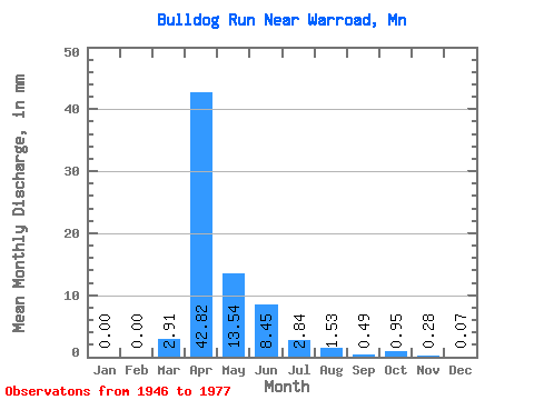
| Statistic | Jan | Feb | Mar | Apr | May | Jun | Jul | Aug | Sep | Oct | Nov | Dec | Annual |
|---|---|---|---|---|---|---|---|---|---|---|---|---|---|
| Mean | 0.00 | 0.00 | 2.90 | 42.83 | 13.57 | 8.47 | 2.87 | 1.55 | 0.51 | 0.96 | 0.30 | 0.04 | 78.12 |
| Standard Deviation | 0.00 | 0.00 | 5.13 | 38.78 | 24.05 | 17.15 | 5.39 | 4.66 | 1.19 | 2.33 | 0.66 | 0.09 | 52.92 |
| Min | 0.00 | 0.00 | 0.00 | 0.41 | 0.06 | 0.00 | 0.00 | 0.00 | 0.00 | 0.00 | 0.00 | 0.00 | 5.40 |
| Max | 0.00 | 0.00 | 15.65 | 143.28 | 87.34 | 66.23 | 18.34 | 19.91 | 4.16 | 8.08 | 2.62 | 0.35 | 179.75 |
| Coefficient of Variation | 1.77 | 0.91 | 1.77 | 2.02 | 1.88 | 3.00 | 2.32 | 2.43 | 2.24 | 2.45 | 0.68 |
 Return to R-Arctic Net Home Page