|
|
|||||||||||||||||
| Point ID: 9619 | Downloads | Plots | Site Data | Code: 05093000 |
|
|
|||||||||||||||||
| Download | |
|---|---|
| Site Descriptor Information | Site Time Series Data |
| Link to all available data | |
| View: | Time Series | All |
| Units: | m3/s |
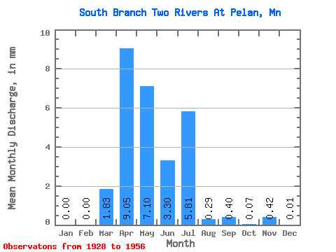
| Statistic | Jan | Feb | Mar | Apr | May | Jun | Jul | Aug | Sep | Oct | Nov | Dec | Annual |
|---|---|---|---|---|---|---|---|---|---|---|---|---|---|
| Mean | 0.00 | 0.00 | 1.82 | 9.05 | 7.10 | 3.30 | 5.81 | 0.29 | 0.40 | 0.07 | 0.41 | 0.01 | 19.14 |
| Standard Deviation | 0.00 | 0.00 | 5.53 | 9.79 | 8.41 | 6.87 | 20.14 | 0.64 | 1.19 | 0.16 | 1.47 | 0.03 | 13.57 |
| Min | 0.00 | 0.00 | 0.00 | 0.75 | 0.05 | 0.00 | 0.00 | 0.00 | 0.00 | 0.00 | 0.00 | 0.00 | 0.95 |
| Max | 0.00 | 0.00 | 20.10 | 34.79 | 28.94 | 24.55 | 72.83 | 1.89 | 4.39 | 0.54 | 5.53 | 0.10 | 36.88 |
| Coefficient of Variation | 3.03 | 1.08 | 1.18 | 2.08 | 3.46 | 2.25 | 2.97 | 2.34 | 3.55 | 3.12 | 0.71 |
 Return to R-Arctic Net Home Page