|
|
|||||||||||||||||
| Point ID: 9616 | Downloads | Plots | Site Data | Code: 05126500 |
|
|
|||||||||||||||||
| Download | |
|---|---|
| Site Descriptor Information | Site Time Series Data |
| Link to all available data | |
| View: | Time Series | All |
| Units: | m3/s |
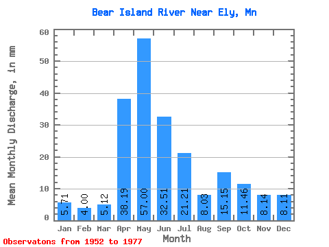
| Statistic | Jan | Feb | Mar | Apr | May | Jun | Jul | Aug | Sep | Oct | Nov | Dec | Annual |
|---|---|---|---|---|---|---|---|---|---|---|---|---|---|
| Mean | 5.71 | 4.03 | 5.11 | 38.20 | 56.99 | 32.51 | 21.20 | 8.04 | 15.15 | 11.46 | 8.13 | 8.11 | 200.75 |
| Standard Deviation | 2.93 | 1.85 | 2.21 | 23.85 | 33.16 | 15.00 | 14.47 | 7.57 | 22.97 | 15.54 | 4.56 | 4.54 | 67.37 |
| Min | 0.00 | 0.00 | 1.38 | 4.48 | 14.36 | 12.37 | 3.50 | 1.05 | 0.17 | 0.25 | 0.09 | 0.00 | 100.65 |
| Max | 12.00 | 7.74 | 9.62 | 83.04 | 132.03 | 57.12 | 52.26 | 26.45 | 80.60 | 58.31 | 15.31 | 18.01 | 318.76 |
| Coefficient of Variation | 0.51 | 0.46 | 0.43 | 0.62 | 0.58 | 0.46 | 0.68 | 0.94 | 1.52 | 1.36 | 0.56 | 0.56 | 0.34 |
 Return to R-Arctic Net Home Page