|
|
|||||||||||||||||
| Point ID: 9605 | Downloads | Plots | Site Data | Code: 05056215 |
|
|
|||||||||||||||||
| Download | |
|---|---|
| Site Descriptor Information | Site Time Series Data |
| Link to all available data | |
| View: | Time Series | All |
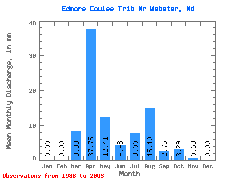
| Units: | m3/s |
| Statistic | Jan | Feb | Mar | Apr | May | Jun | Jul | Aug | Sep | Oct | Nov | Dec | Annual |
|---|---|---|---|---|---|---|---|---|---|---|---|---|---|
| Mean | 0.00 | 0.00 | 5.89 | 26.53 | 8.72 | 3.15 | 5.63 | 10.61 | 1.93 | 2.31 | 0.48 | 0.00 | |
| Standard Deviation | 12.09 | 27.73 | 16.03 | 4.94 | 10.56 | 39.76 | 5.97 | 3.27 | |||||
| Min | 0.00 | 0.00 | 0.00 | 0.00 | 0.00 | 0.00 | 0.00 | 0.00 | 0.00 | 0.00 | 0.48 | 0.00 | |
| Max | 0.00 | 0.00 | 46.19 | 94.35 | 59.89 | 18.99 | 44.80 | 169.80 | 25.57 | 4.63 | 0.48 | 0.00 | |
| Coefficient of Variation | 2.05 | 1.04 | 1.84 | 1.57 | 1.88 | 3.75 | 3.09 | 1.41 |
 Return to R-Arctic Net Home Page