|
|
|||||||||||||||||
| Point ID: 9597 | Downloads | Plots | Site Data | Code: 05124990 |
|
|
|||||||||||||||||
| Download | |
|---|---|
| Site Descriptor Information | Site Time Series Data |
| Link to all available data | |
| View: | Time Series | All |
| Units: | m3/s |
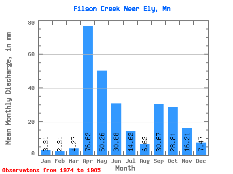
| Statistic | Jan | Feb | Mar | Apr | May | Jun | Jul | Aug | Sep | Oct | Nov | Dec | Annual |
|---|---|---|---|---|---|---|---|---|---|---|---|---|---|
| Mean | 3.31 | 2.29 | 4.27 | 76.58 | 50.27 | 30.86 | 14.65 | 6.56 | 30.66 | 28.81 | 16.16 | 7.52 | 274.15 |
| Standard Deviation | 2.23 | 1.33 | 4.21 | 40.63 | 27.38 | 14.96 | 10.25 | 8.93 | 56.89 | 29.62 | 13.71 | 5.81 | 48.10 |
| Min | 0.00 | 0.00 | 1.31 | 5.06 | 14.47 | 4.39 | 2.99 | 0.42 | 0.05 | 0.28 | 0.52 | 0.33 | 203.13 |
| Max | 6.87 | 4.53 | 16.11 | 138.90 | 99.33 | 53.72 | 31.80 | 28.77 | 180.63 | 77.09 | 46.61 | 18.59 | 336.71 |
| Coefficient of Variation | 0.67 | 0.58 | 0.99 | 0.53 | 0.55 | 0.48 | 0.70 | 1.36 | 1.86 | 1.03 | 0.85 | 0.77 | 0.17 |
 Return to R-Arctic Net Home Page