|
|
|||||||||||||||||
| Point ID: 9594 | Downloads | Plots | Site Data | Code: 05055200 |
|
|
|||||||||||||||||
| Download | |
|---|---|
| Site Descriptor Information | Site Time Series Data |
| Link to all available data | |
| View: | Time Series | All |
| Units: | m3/s |
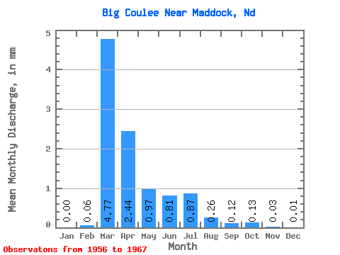
| Statistic | Jan | Feb | Mar | Apr | May | Jun | Jul | Aug | Sep | Oct | Nov | Dec | Annual |
|---|---|---|---|---|---|---|---|---|---|---|---|---|---|
| Mean | 0.00 | 0.04 | 3.07 | 1.56 | 0.62 | 0.52 | 0.56 | 0.17 | 0.08 | 0.08 | 0.02 | 0.01 | 5.89 |
| Standard Deviation | 0.01 | 0.13 | 4.65 | 1.91 | 0.78 | 0.86 | 0.84 | 0.35 | 0.22 | 0.26 | 0.06 | 0.03 | 5.57 |
| Min | 0.00 | 0.00 | 0.01 | 0.00 | 0.00 | 0.00 | 0.00 | 0.00 | 0.00 | 0.00 | 0.00 | 0.00 | 0.80 |
| Max | 0.02 | 0.44 | 14.56 | 5.67 | 2.57 | 2.86 | 2.52 | 0.88 | 0.74 | 0.86 | 0.18 | 0.09 | 17.69 |
| Coefficient of Variation | 3.32 | 3.32 | 1.52 | 1.22 | 1.26 | 1.65 | 1.51 | 2.04 | 2.82 | 3.26 | 2.92 | 3.32 | 0.95 |
 Return to R-Arctic Net Home Page