|
|
|||||||||||||||||
| Point ID: 9583 | Downloads | Plots | Site Data | Code: 05060100 |
|
|
|||||||||||||||||
| Download | |
|---|---|
| Site Descriptor Information | Site Time Series Data |
| Link to all available data | |
| View: | Time Series | All |
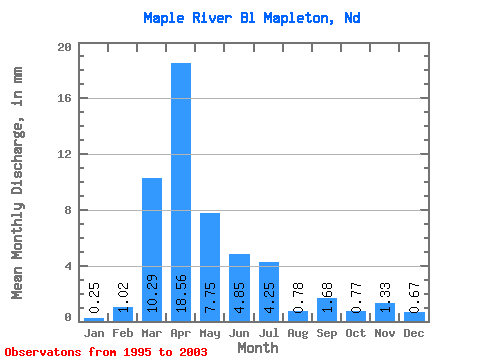
| Units: | m3/s |
| Statistic | Jan | Feb | Mar | Apr | May | Jun | Jul | Aug | Sep | Oct | Nov | Dec | Annual |
|---|---|---|---|---|---|---|---|---|---|---|---|---|---|
| Mean | 0.24 | 0.98 | 9.80 | 17.68 | 7.38 | 4.62 | 4.04 | 0.74 | 1.60 | 0.73 | 1.26 | 0.64 | 55.74 |
| Standard Deviation | 0.13 | 1.88 | 10.47 | 19.52 | 6.28 | 4.97 | 1.91 | 0.31 | 2.50 | 0.59 | 1.66 | 0.82 | 24.71 |
| Min | 0.04 | 0.01 | 0.06 | 0.80 | 1.15 | 0.89 | 1.55 | 0.27 | 0.13 | 0.20 | 0.27 | 0.14 | 12.91 |
| Max | 0.41 | 5.20 | 27.22 | 56.60 | 20.48 | 16.60 | 7.38 | 1.13 | 7.68 | 1.91 | 4.91 | 2.47 | 80.69 |
| Coefficient of Variation | 0.56 | 1.91 | 1.07 | 1.10 | 0.85 | 1.08 | 0.47 | 0.42 | 1.56 | 0.81 | 1.32 | 1.27 | 0.44 |
 Return to R-Arctic Net Home Page