|
|
|||||||||||||||||
| Point ID: 9581 | Downloads | Plots | Site Data | Code: 05097500 |
|
|
|||||||||||||||||
| Download | |
|---|---|
| Site Descriptor Information | Site Time Series Data |
| Link to all available data | |
| View: | Time Series | All |
| Units: | m3/s |
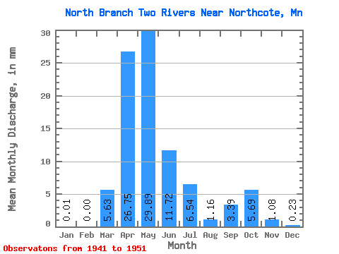
| Statistic | Jan | Feb | Mar | Apr | May | Jun | Jul | Aug | Sep | Oct | Nov | Dec | Annual |
|---|---|---|---|---|---|---|---|---|---|---|---|---|---|
| Mean | 0.01 | 0.00 | 5.63 | 26.75 | 29.89 | 11.72 | 6.54 | 1.16 | 3.38 | 5.69 | 1.08 | 0.23 | 99.67 |
| Standard Deviation | 0.02 | 0.01 | 8.81 | 16.14 | 48.96 | 16.56 | 10.97 | 1.39 | 4.42 | 8.78 | 1.21 | 0.25 | 113.04 |
| Min | 0.00 | 0.00 | 0.00 | 5.24 | 1.40 | 0.11 | 0.10 | 0.00 | 0.00 | 0.00 | 0.01 | 0.01 | 28.16 |
| Max | 0.06 | 0.03 | 22.60 | 48.57 | 157.09 | 52.79 | 30.10 | 3.42 | 13.75 | 26.24 | 3.69 | 0.70 | 295.18 |
| Coefficient of Variation | 2.65 | 2.65 | 1.56 | 0.60 | 1.64 | 1.41 | 1.68 | 1.20 | 1.30 | 1.54 | 1.12 | 1.09 | 1.13 |
 Return to R-Arctic Net Home Page