|
|
|||||||||||||||||
| Point ID: 9522 | Downloads | Plots | Site Data | Code: 15292400 |
|
|
|||||||||||||||||
| Download | |
|---|---|
| Site Descriptor Information | Site Time Series Data |
| Link to all available data | |
| View: | Time Series | All |
| Units: | m3/s |
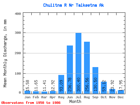
| Statistic | Jan | Feb | Mar | Apr | May | Jun | Jul | Aug | Sep | Oct | Nov | Dec | Annual |
|---|---|---|---|---|---|---|---|---|---|---|---|---|---|
| Mean | 15.58 | 11.76 | 11.41 | 12.92 | 93.07 | 236.78 | 300.35 | 256.52 | 130.50 | 59.11 | 23.92 | 17.95 | 1173.04 |
| Standard Deviation | 3.34 | 1.96 | 1.82 | 2.52 | 33.18 | 57.68 | 43.22 | 54.26 | 39.95 | 16.15 | 5.46 | 4.18 | 125.82 |
| Min | 11.10 | 8.51 | 8.41 | 7.72 | 26.83 | 162.24 | 237.22 | 128.79 | 73.92 | 33.02 | 16.32 | 11.39 | 841.36 |
| Max | 23.30 | 15.64 | 14.81 | 17.64 | 158.28 | 444.74 | 405.25 | 383.64 | 245.49 | 98.18 | 35.43 | 27.20 | 1465.15 |
| Coefficient of Variation | 0.21 | 0.17 | 0.16 | 0.20 | 0.36 | 0.24 | 0.14 | 0.21 | 0.31 | 0.27 | 0.23 | 0.23 | 0.11 |
 Return to R-Arctic Net Home Page