|
|
|||||||||||||||||
| Point ID: 9520 | Downloads | Plots | Site Data | Code: 15291500 |
|
|
|||||||||||||||||
| Download | |
|---|---|
| Site Descriptor Information | Site Time Series Data |
| Link to all available data | |
| View: | Time Series | All |
| Units: | m3/s |
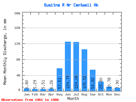
| Statistic | Jan | Feb | Mar | Apr | May | Jun | Jul | Aug | Sep | Oct | Nov | Dec | Annual |
|---|---|---|---|---|---|---|---|---|---|---|---|---|---|
| Mean | 6.79 | 5.34 | 5.51 | 6.26 | 57.50 | 124.79 | 124.06 | 105.50 | 54.32 | 23.80 | 10.78 | 7.90 | 525.51 |
| Standard Deviation | 2.52 | 1.95 | 2.06 | 1.99 | 19.99 | 37.97 | 19.45 | 29.29 | 16.56 | 7.38 | 3.36 | 2.46 | 90.26 |
| Min | 3.09 | 2.74 | 3.03 | 3.18 | 13.54 | 67.83 | 86.39 | 46.66 | 23.11 | 11.59 | 5.34 | 3.84 | 339.04 |
| Max | 11.98 | 9.66 | 10.47 | 9.61 | 85.92 | 237.02 | 161.18 | 161.00 | 88.36 | 38.70 | 17.02 | 11.73 | 673.64 |
| Coefficient of Variation | 0.37 | 0.37 | 0.38 | 0.32 | 0.35 | 0.30 | 0.16 | 0.28 | 0.30 | 0.31 | 0.31 | 0.31 | 0.17 |
 Return to R-Arctic Net Home Page