|
|
|||||||||||||||||
| Point ID: 9515 | Downloads | Plots | Site Data | Code: 15284000 |
|
|
|||||||||||||||||
| Download | |
|---|---|
| Site Descriptor Information | Site Time Series Data |
| Link to all available data | |
| View: | Time Series | All |
| Units: | m3/s |
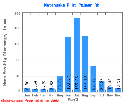
| Statistic | Jan | Feb | Mar | Apr | May | Jun | Jul | Aug | Sep | Oct | Nov | Dec | Annual |
|---|---|---|---|---|---|---|---|---|---|---|---|---|---|
| Mean | 8.80 | 6.70 | 6.70 | 8.82 | 39.33 | 138.57 | 185.03 | 140.17 | 65.77 | 27.28 | 13.48 | 10.31 | 648.05 |
| Standard Deviation | 1.59 | 0.85 | 0.84 | 1.86 | 17.13 | 42.30 | 30.44 | 29.51 | 21.27 | 7.35 | 3.94 | 2.16 | 84.79 |
| Min | 4.93 | 4.91 | 5.09 | 6.37 | 14.25 | 74.14 | 130.22 | 70.61 | 29.06 | 16.50 | 7.78 | 6.22 | 426.45 |
| Max | 11.61 | 8.11 | 8.24 | 13.49 | 85.14 | 236.11 | 265.18 | 222.48 | 122.74 | 43.74 | 24.55 | 14.49 | 815.55 |
| Coefficient of Variation | 0.18 | 0.13 | 0.12 | 0.21 | 0.43 | 0.30 | 0.17 | 0.21 | 0.32 | 0.27 | 0.29 | 0.21 | 0.13 |
 Return to R-Arctic Net Home Page