|
|
|||||||||||||||||
| Point ID: 9507 | Downloads | Plots | Site Data | Code: 15277600 |
|
|
|||||||||||||||||
| Download | |
|---|---|
| Site Descriptor Information | Site Time Series Data |
| Link to all available data | |
| View: | Time Series | All |
| Units: | m3/s |
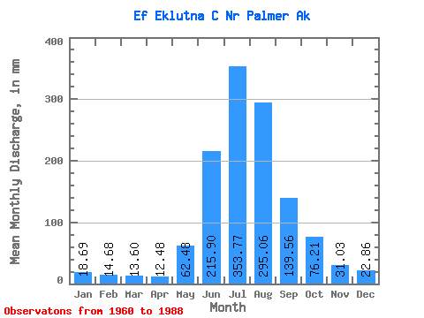
| Statistic | Jan | Feb | Mar | Apr | May | Jun | Jul | Aug | Sep | Oct | Nov | Dec | Annual |
|---|---|---|---|---|---|---|---|---|---|---|---|---|---|
| Mean | 18.69 | 14.80 | 13.60 | 12.46 | 62.47 | 215.90 | 353.73 | 295.01 | 139.57 | 76.19 | 31.03 | 22.86 | 1288.59 |
| Standard Deviation | 5.47 | 5.46 | 6.05 | 5.68 | 20.42 | 62.69 | 33.85 | 44.23 | 16.65 | 27.49 | 8.20 | 4.48 | 95.68 |
| Min | 15.58 | 11.05 | 7.81 | 7.99 | 46.90 | 118.84 | 308.25 | 246.16 | 120.47 | 45.49 | 19.05 | 17.73 | 1187.91 |
| Max | 28.38 | 23.76 | 23.02 | 22.28 | 97.23 | 314.24 | 420.52 | 341.58 | 168.54 | 127.68 | 40.44 | 30.62 | 1384.55 |
| Coefficient of Variation | 0.29 | 0.37 | 0.45 | 0.46 | 0.33 | 0.29 | 0.10 | 0.15 | 0.12 | 0.36 | 0.26 | 0.20 | 0.07 |
 Return to R-Arctic Net Home Page