|
|
|||||||||||||||||
| Point ID: 9492 | Downloads | Plots | Site Data | Code: 15296480 |
|
|
|||||||||||||||||
| Download | |
|---|---|
| Site Descriptor Information | Site Time Series Data |
| Link to all available data | |
| View: | Time Series | All |
| Units: | m3/s |
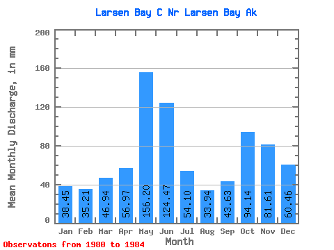
| Statistic | Jan | Feb | Mar | Apr | May | Jun | Jul | Aug | Sep | Oct | Nov | Dec | Annual |
|---|---|---|---|---|---|---|---|---|---|---|---|---|---|
| Mean | 38.54 | 35.42 | 46.90 | 57.07 | 156.09 | 124.39 | 54.02 | 33.84 | 43.69 | 94.04 | 81.70 | 60.46 | 844.23 |
| Standard Deviation | 9.04 | 16.55 | 11.71 | 23.43 | 50.66 | 43.75 | 17.96 | 4.93 | 13.07 | 43.63 | 21.94 | 24.08 | 32.87 |
| Min | 29.18 | 16.31 | 31.21 | 28.80 | 107.78 | 89.13 | 42.16 | 27.55 | 26.86 | 51.65 | 67.87 | 34.88 | 811.52 |
| Max | 49.67 | 51.78 | 56.66 | 79.22 | 227.42 | 188.22 | 80.34 | 38.53 | 57.72 | 155.09 | 114.04 | 90.95 | 877.26 |
| Coefficient of Variation | 0.23 | 0.47 | 0.25 | 0.41 | 0.33 | 0.35 | 0.33 | 0.15 | 0.30 | 0.46 | 0.27 | 0.40 | 0.04 |
 Return to R-Arctic Net Home Page