|
|
|||||||||||||||||
| Point ID: 9466 | Downloads | Plots | Site Data | Code: 15241600 |
|
|
|||||||||||||||||
| Download | |
|---|---|
| Site Descriptor Information | Site Time Series Data |
| Link to all available data | |
| View: | Time Series | All |
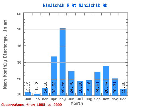
| Units: | m3/s |
| Statistic | Jan | Feb | Mar | Apr | May | Jun | Jul | Aug | Sep | Oct | Nov | Dec | Annual |
|---|---|---|---|---|---|---|---|---|---|---|---|---|---|
| Mean | 12.15 | 11.27 | 14.56 | 33.52 | 50.55 | 24.70 | 18.86 | 19.16 | 24.51 | 28.03 | 20.31 | 13.88 | 272.37 |
| Standard Deviation | 2.65 | 2.76 | 5.16 | 21.84 | 19.50 | 9.25 | 5.63 | 6.15 | 8.14 | 8.62 | 12.99 | 2.93 | 46.82 |
| Min | 7.99 | 7.11 | 8.01 | 8.69 | 17.72 | 13.07 | 12.49 | 10.36 | 11.47 | 16.96 | 8.63 | 9.11 | 152.78 |
| Max | 18.66 | 18.56 | 32.10 | 115.08 | 105.85 | 49.90 | 32.71 | 33.62 | 42.79 | 47.88 | 65.97 | 21.38 | 348.12 |
| Coefficient of Variation | 0.22 | 0.24 | 0.35 | 0.65 | 0.39 | 0.37 | 0.30 | 0.32 | 0.33 | 0.31 | 0.64 | 0.21 | 0.17 |
 Return to R-Arctic Net Home Page