|
|
|||||||||||||||||
| Point ID: 9464 | Downloads | Plots | Site Data | Code: 15239900 |
|
|
|||||||||||||||||
| Download | |
|---|---|
| Site Descriptor Information | Site Time Series Data |
| Link to all available data | |
| View: | Time Series | All |
| Units: | m3/s |
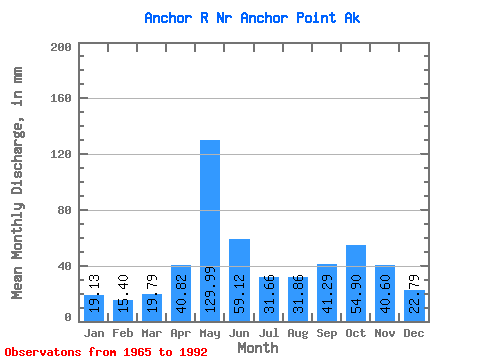
| Statistic | Jan | Feb | Mar | Apr | May | Jun | Jul | Aug | Sep | Oct | Nov | Dec | Annual |
|---|---|---|---|---|---|---|---|---|---|---|---|---|---|
| Mean | 19.13 | 15.54 | 19.78 | 40.82 | 129.97 | 59.12 | 31.66 | 31.86 | 41.29 | 54.89 | 40.59 | 22.79 | 516.12 |
| Standard Deviation | 8.00 | 5.51 | 10.98 | 21.33 | 44.78 | 35.99 | 13.80 | 12.63 | 20.04 | 24.07 | 34.84 | 10.72 | 119.68 |
| Min | 5.99 | 6.75 | 9.51 | 11.34 | 40.82 | 25.55 | 17.62 | 11.85 | 12.25 | 24.86 | 7.14 | 6.42 | 353.77 |
| Max | 42.40 | 26.92 | 47.41 | 72.33 | 236.71 | 166.21 | 61.44 | 63.35 | 79.06 | 111.09 | 134.98 | 46.10 | 818.61 |
| Coefficient of Variation | 0.42 | 0.35 | 0.56 | 0.52 | 0.34 | 0.61 | 0.44 | 0.40 | 0.48 | 0.44 | 0.86 | 0.47 | 0.23 |
 Return to R-Arctic Net Home Page