|
|
|||||||||||||||||
| Point ID: 9452 | Downloads | Plots | Site Data | Code: 15275100 |
|
|
|||||||||||||||||
| Download | |
|---|---|
| Site Descriptor Information | Site Time Series Data |
| Link to all available data | |
| View: | Time Series | All |
| Units: | m3/s |
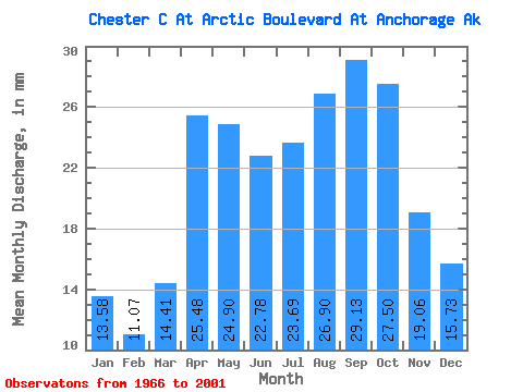
| Statistic | Jan | Feb | Mar | Apr | May | Jun | Jul | Aug | Sep | Oct | Nov | Dec | Annual |
|---|---|---|---|---|---|---|---|---|---|---|---|---|---|
| Mean | 13.57 | 11.16 | 14.41 | 25.47 | 24.89 | 22.78 | 23.68 | 26.89 | 29.12 | 27.50 | 19.05 | 15.74 | 254.08 |
| Standard Deviation | 5.56 | 4.08 | 4.85 | 10.12 | 10.07 | 7.46 | 6.67 | 10.11 | 10.86 | 9.94 | 7.94 | 6.17 | 67.73 |
| Min | 3.49 | 2.90 | 4.47 | 10.99 | 11.76 | 10.42 | 10.79 | 10.25 | 12.95 | 11.45 | 8.55 | 4.09 | 129.60 |
| Max | 28.32 | 19.60 | 26.91 | 60.34 | 59.71 | 46.38 | 37.12 | 65.53 | 61.75 | 56.12 | 47.00 | 35.38 | 415.67 |
| Coefficient of Variation | 0.41 | 0.37 | 0.34 | 0.40 | 0.41 | 0.33 | 0.28 | 0.38 | 0.37 | 0.36 | 0.42 | 0.39 | 0.27 |
 Return to R-Arctic Net Home Page