|
|
|||||||||||||||||
| Point ID: 9427 | Downloads | Plots | Site Data | Code: 15564885 |
|
|
|||||||||||||||||
| Download | |
|---|---|
| Site Descriptor Information | Site Time Series Data |
| Link to all available data | |
| View: | Time Series | All |
| Units: | m3/s |
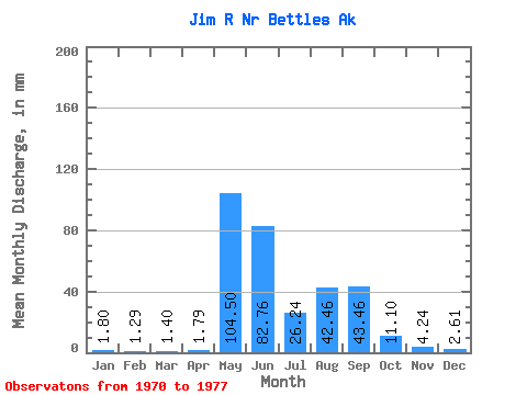
| Statistic | Jan | Feb | Mar | Apr | May | Jun | Jul | Aug | Sep | Oct | Nov | Dec | Annual |
|---|---|---|---|---|---|---|---|---|---|---|---|---|---|
| Mean | 1.80 | 1.30 | 1.40 | 1.79 | 104.49 | 82.76 | 26.24 | 42.46 | 43.46 | 11.09 | 4.24 | 2.61 | 317.70 |
| Standard Deviation | 0.91 | 0.70 | 0.74 | 0.91 | 37.10 | 23.43 | 13.03 | 15.56 | 25.07 | 5.33 | 1.85 | 1.23 | 70.92 |
| Min | 0.48 | 0.31 | 0.34 | 0.38 | 73.17 | 51.04 | 14.25 | 19.10 | 23.61 | 5.42 | 2.13 | 0.89 | 229.61 |
| Max | 2.96 | 2.24 | 2.44 | 2.96 | 177.22 | 109.46 | 48.92 | 60.66 | 82.62 | 21.50 | 6.45 | 4.39 | 408.85 |
| Coefficient of Variation | 0.51 | 0.54 | 0.53 | 0.51 | 0.35 | 0.28 | 0.50 | 0.37 | 0.58 | 0.48 | 0.44 | 0.47 | 0.22 |
 Return to R-Arctic Net Home Page