|
|
|||||||||||||||||
| Point ID: 9405 | Downloads | Plots | Site Data | Code: 15798700 |
|
|
|||||||||||||||||
| Download | |
|---|---|
| Site Descriptor Information | Site Time Series Data |
| Link to all available data | |
| View: | Time Series | All |
| Units: | m3/s |
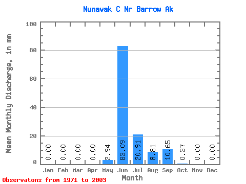
| Statistic | Jan | Feb | Mar | Apr | May | Jun | Jul | Aug | Sep | Oct | Nov | Dec | Annual |
|---|---|---|---|---|---|---|---|---|---|---|---|---|---|
| Mean | 0.00 | 0.00 | 0.00 | 0.00 | 2.80 | 83.17 | 20.73 | 8.89 | 10.55 | 0.30 | 0.00 | 0.00 | 128.56 |
| Standard Deviation | 0.00 | 0.00 | 0.00 | 0.00 | 8.55 | 42.13 | 22.13 | 15.38 | 18.77 | 0.71 | 0.00 | 0.00 | 67.08 |
| Min | 0.00 | 0.00 | 0.00 | 0.00 | 0.00 | 27.43 | 1.10 | 0.00 | 0.00 | 0.00 | 0.00 | 0.00 | 31.61 |
| Max | 0.00 | 0.00 | 0.00 | 0.00 | 36.86 | 173.85 | 103.08 | 70.51 | 83.86 | 2.26 | 0.00 | 0.00 | 279.74 |
| Coefficient of Variation | 3.06 | 0.51 | 1.07 | 1.73 | 1.78 | 2.37 | 0.52 |
 Return to R-Arctic Net Home Page