|
|
|||||||||||||||||
| Point ID: 9400 | Downloads | Plots | Site Data | Code: 15904900 |
|
|
|||||||||||||||||
| Download | |
|---|---|
| Site Descriptor Information | Site Time Series Data |
| Link to all available data | |
| View: | Time Series | All |
| Units: | m3/s |
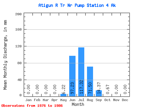
| Statistic | Jan | Feb | Mar | Apr | May | Jun | Jul | Aug | Sep | Oct | Nov | Dec | Annual |
|---|---|---|---|---|---|---|---|---|---|---|---|---|---|
| Mean | 0.00 | 0.00 | 0.00 | 0.00 | 6.22 | 97.23 | 117.31 | 71.48 | 14.38 | 0.68 | 0.00 | 0.00 | 303.93 |
| Standard Deviation | 0.00 | 0.00 | 0.00 | 0.00 | 4.50 | 31.41 | 18.25 | 22.16 | 8.99 | 0.71 | 0.00 | 0.00 | 43.53 |
| Min | 0.00 | 0.00 | 0.00 | 0.00 | 0.20 | 66.47 | 84.15 | 41.07 | 3.94 | 0.00 | 0.00 | 0.00 | 219.06 |
| Max | 0.00 | 0.00 | 0.00 | 0.00 | 14.44 | 156.45 | 133.42 | 99.71 | 29.42 | 2.09 | 0.00 | 0.00 | 365.56 |
| Coefficient of Variation | 0.72 | 0.32 | 0.16 | 0.31 | 0.62 | 1.05 | 0.14 |
 Return to R-Arctic Net Home Page