|
|
|||||||||||||||||
| Point ID: 9375 | Downloads | Plots | Site Data | Code: 15297900 |
|
|
|||||||||||||||||
| Download | |
|---|---|
| Site Descriptor Information | Site Time Series Data |
| Link to all available data | |
| View: | Time Series | All |
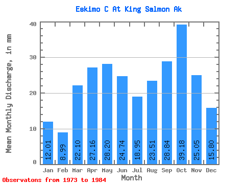
| Units: | m3/s |
| Statistic | Jan | Feb | Mar | Apr | May | Jun | Jul | Aug | Sep | Oct | Nov | Dec | Annual |
|---|---|---|---|---|---|---|---|---|---|---|---|---|---|
| Mean | 12.02 | 9.08 | 22.11 | 27.18 | 28.18 | 24.71 | 18.92 | 23.52 | 28.85 | 39.20 | 25.03 | 15.81 | 272.93 |
| Standard Deviation | 3.90 | 3.38 | 13.64 | 9.24 | 26.92 | 12.46 | 8.45 | 11.10 | 17.65 | 11.00 | 11.94 | 7.40 | 34.54 |
| Min | 6.21 | 6.73 | 9.40 | 12.47 | 13.93 | 12.78 | 7.58 | 11.95 | 12.71 | 22.91 | 13.73 | 7.25 | 237.69 |
| Max | 17.18 | 17.91 | 44.06 | 41.60 | 103.06 | 50.49 | 38.66 | 49.34 | 68.65 | 65.06 | 54.51 | 30.45 | 327.89 |
| Coefficient of Variation | 0.32 | 0.37 | 0.62 | 0.34 | 0.95 | 0.50 | 0.45 | 0.47 | 0.61 | 0.28 | 0.48 | 0.47 | 0.13 |
 Return to R-Arctic Net Home Page