|
|
|||||||||||||||||
| Point ID: 9367 | Downloads | Plots | Site Data | Code: 15297650 |
|
|
|||||||||||||||||
| Download | |
|---|---|
| Site Descriptor Information | Site Time Series Data |
| Link to all available data | |
| View: | Time Series | All |
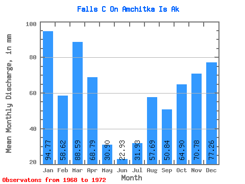
| Units: | m3/s |
| Statistic | Jan | Feb | Mar | Apr | May | Jun | Jul | Aug | Sep | Oct | Nov | Dec | Annual |
|---|---|---|---|---|---|---|---|---|---|---|---|---|---|
| Mean | 94.93 | 59.45 | 88.19 | 68.80 | 30.52 | 22.92 | 31.67 | 57.17 | 50.45 | 65.02 | 71.11 | 76.88 | 781.00 |
| Standard Deviation | 18.80 | 22.23 | 22.46 | 31.70 | 13.48 | 9.96 | 13.75 | 39.39 | 25.52 | 17.42 | 12.13 | 31.44 | 103.88 |
| Min | 70.54 | 43.07 | 63.13 | 28.61 | 10.66 | 8.11 | 13.39 | 14.75 | 27.28 | 42.76 | 60.21 | 32.93 | 719.28 |
| Max | 110.28 | 90.23 | 106.49 | 95.54 | 40.27 | 29.64 | 43.26 | 103.03 | 85.64 | 84.92 | 86.43 | 103.07 | 900.93 |
| Coefficient of Variation | 0.20 | 0.37 | 0.26 | 0.46 | 0.44 | 0.43 | 0.43 | 0.69 | 0.51 | 0.27 | 0.17 | 0.41 | 0.13 |
 Return to R-Arctic Net Home Page