|
|
|||||||||||||||||
| Point ID: 9366 | Downloads | Plots | Site Data | Code: 15297640 |
|
|
|||||||||||||||||
| Download | |
|---|---|
| Site Descriptor Information | Site Time Series Data |
| Link to all available data | |
| View: | Time Series | All |
| Units: | m3/s |
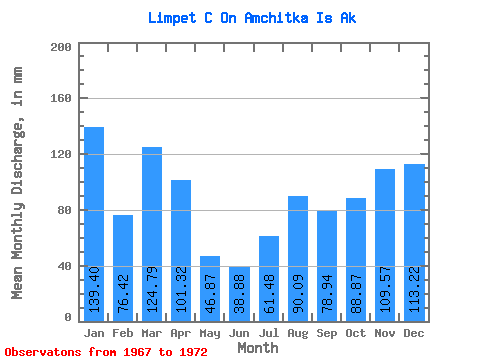
| Statistic | Jan | Feb | Mar | Apr | May | Jun | Jul | Aug | Sep | Oct | Nov | Dec | Annual |
|---|---|---|---|---|---|---|---|---|---|---|---|---|---|
| Mean | 139.14 | 77.35 | 124.68 | 101.11 | 47.14 | 39.10 | 61.59 | 90.15 | 79.04 | 88.99 | 109.43 | 113.26 | 1050.84 |
| Standard Deviation | 23.82 | 27.70 | 57.06 | 42.75 | 13.77 | 5.89 | 20.27 | 47.89 | 32.85 | 30.25 | 19.55 | 46.28 | 185.52 |
| Min | 114.05 | 49.81 | 77.47 | 65.11 | 31.59 | 33.60 | 38.95 | 37.19 | 43.49 | 56.17 | 90.19 | 46.20 | 804.28 |
| Max | 171.05 | 116.89 | 214.79 | 148.35 | 58.86 | 46.70 | 93.73 | 145.76 | 125.08 | 117.62 | 136.77 | 170.30 | 1219.44 |
| Coefficient of Variation | 0.17 | 0.36 | 0.46 | 0.42 | 0.29 | 0.15 | 0.33 | 0.53 | 0.42 | 0.34 | 0.18 | 0.41 | 0.18 |
 Return to R-Arctic Net Home Page