|
|
|||||||||||||||||
| Point ID: 9360 | Downloads | Plots | Site Data | Code: 15297485 |
|
|
|||||||||||||||||
| Download | |
|---|---|
| Site Descriptor Information | Site Time Series Data |
| Link to all available data | |
| View: | Time Series | All |
| Units: | m3/s |
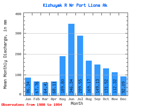
| Statistic | Jan | Feb | Mar | Apr | May | Jun | Jul | Aug | Sep | Oct | Nov | Dec | Annual |
|---|---|---|---|---|---|---|---|---|---|---|---|---|---|
| Mean | 86.32 | 68.34 | 64.41 | 68.11 | 189.78 | 346.34 | 289.51 | 169.15 | 149.13 | 131.50 | 112.32 | 92.08 | 1766.61 |
| Standard Deviation | 28.80 | 35.35 | 31.01 | 48.50 | 66.97 | 73.48 | 68.98 | 55.35 | 49.03 | 53.73 | 63.60 | 43.88 | 298.91 |
| Min | 30.13 | 15.07 | 2.85 | 6.00 | 95.40 | 223.02 | 194.82 | 58.09 | 57.76 | 28.50 | 16.87 | 12.08 | 1316.37 |
| Max | 144.07 | 152.53 | 113.68 | 165.31 | 305.26 | 495.44 | 421.03 | 266.67 | 253.71 | 200.89 | 228.13 | 151.49 | 2299.04 |
| Coefficient of Variation | 0.33 | 0.52 | 0.48 | 0.71 | 0.35 | 0.21 | 0.24 | 0.33 | 0.33 | 0.41 | 0.57 | 0.48 | 0.17 |
 Return to R-Arctic Net Home Page