|
|
|||||||||||||||||
| Point ID: 9358 | Downloads | Plots | Site Data | Code: 15297680 |
|
|
|||||||||||||||||
| Download | |
|---|---|
| Site Descriptor Information | Site Time Series Data |
| Link to all available data | |
| View: | Time Series | All |
| Units: | m3/s |
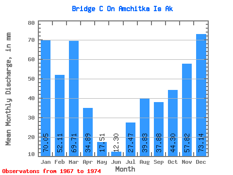
| Statistic | Jan | Feb | Mar | Apr | May | Jun | Jul | Aug | Sep | Oct | Nov | Dec | Annual |
|---|---|---|---|---|---|---|---|---|---|---|---|---|---|
| Mean | 70.02 | 52.47 | 69.68 | 34.77 | 17.58 | 12.23 | 27.37 | 39.78 | 37.79 | 44.36 | 57.96 | 73.00 | 519.81 |
| Standard Deviation | 13.63 | 25.90 | 33.23 | 14.44 | 10.84 | 5.33 | 10.57 | 24.60 | 15.82 | 12.45 | 13.50 | 34.26 | 104.87 |
| Min | 53.49 | 26.32 | 25.47 | 19.53 | 5.66 | 6.05 | 15.45 | 8.89 | 21.72 | 25.58 | 42.58 | 24.21 | 360.31 |
| Max | 92.48 | 89.27 | 118.10 | 56.97 | 38.34 | 21.52 | 48.41 | 70.55 | 58.92 | 61.90 | 79.29 | 129.46 | 636.49 |
| Coefficient of Variation | 0.20 | 0.49 | 0.48 | 0.41 | 0.62 | 0.43 | 0.39 | 0.62 | 0.42 | 0.28 | 0.23 | 0.47 | 0.20 |
 Return to R-Arctic Net Home Page