|
|
|||||||||||||||||
| Point ID: 9353 | Downloads | Plots | Site Data | Code: 15457800 |
|
|
|||||||||||||||||
| Download | |
|---|---|
| Site Descriptor Information | Site Time Series Data |
| Link to all available data | |
| View: | Time Series | All |
| Units: | m3/s |
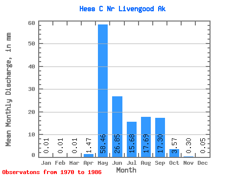
| Statistic | Jan | Feb | Mar | Apr | May | Jun | Jul | Aug | Sep | Oct | Nov | Dec | Annual |
|---|---|---|---|---|---|---|---|---|---|---|---|---|---|
| Mean | 0.01 | 0.01 | 0.01 | 1.47 | 58.45 | 26.85 | 15.68 | 17.68 | 17.30 | 3.57 | 0.30 | 0.05 | 133.93 |
| Standard Deviation | 0.02 | 0.01 | 0.02 | 4.00 | 44.32 | 13.78 | 14.86 | 12.20 | 12.19 | 3.19 | 0.28 | 0.04 | 49.75 |
| Min | 0.00 | 0.00 | 0.00 | 0.00 | 4.83 | 6.39 | 0.89 | 2.10 | 4.48 | 0.65 | 0.05 | 0.00 | 28.21 |
| Max | 0.04 | 0.04 | 0.04 | 14.56 | 171.16 | 48.60 | 51.83 | 34.96 | 40.69 | 10.82 | 1.05 | 0.13 | 209.05 |
| Coefficient of Variation | 1.40 | 1.55 | 1.73 | 2.73 | 0.76 | 0.51 | 0.95 | 0.69 | 0.70 | 0.90 | 0.91 | 0.83 | 0.37 |
 Return to R-Arctic Net Home Page