|
|
|||||||||||||||||
| Point ID: 9352 | Downloads | Plots | Site Data | Code: 15439800 |
|
|
|||||||||||||||||
| Download | |
|---|---|
| Site Descriptor Information | Site Time Series Data |
| Link to all available data | |
| View: | Time Series | All |
| Units: | m3/s |
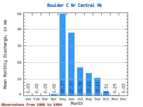
| Statistic | Jan | Feb | Mar | Apr | May | Jun | Jul | Aug | Sep | Oct | Nov | Dec | Annual |
|---|---|---|---|---|---|---|---|---|---|---|---|---|---|
| Mean | 0.03 | 0.02 | 0.03 | 1.02 | 49.38 | 37.96 | 16.97 | 13.61 | 10.60 | 2.51 | 0.30 | 0.04 | 129.87 |
| Standard Deviation | 0.11 | 0.10 | 0.11 | 1.90 | 24.87 | 21.70 | 10.43 | 19.14 | 6.77 | 1.78 | 0.42 | 0.11 | 49.77 |
| Min | 0.00 | 0.00 | 0.00 | 0.00 | 17.10 | 5.96 | 2.81 | 0.82 | 0.72 | 0.17 | 0.00 | 0.00 | 41.38 |
| Max | 0.46 | 0.42 | 0.46 | 7.42 | 100.17 | 78.64 | 38.40 | 90.83 | 25.59 | 6.70 | 1.63 | 0.46 | 222.88 |
| Coefficient of Variation | 3.91 | 4.24 | 4.24 | 1.86 | 0.50 | 0.57 | 0.61 | 1.41 | 0.64 | 0.71 | 1.41 | 2.87 | 0.38 |
 Return to R-Arctic Net Home Page