|
|
|||||||||||||||||
| Point ID: 9350 | Downloads | Plots | Site Data | Code: 15344000 |
|
|
|||||||||||||||||
| Download | |
|---|---|
| Site Descriptor Information | Site Time Series Data |
| Link to all available data | |
| View: | Time Series | All |
| Units: | m3/s |
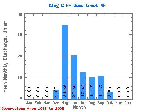
| Statistic | Jan | Feb | Mar | Apr | May | Jun | Jul | Aug | Sep | Oct | Nov | Dec | Annual |
|---|---|---|---|---|---|---|---|---|---|---|---|---|---|
| Mean | 0.00 | 0.00 | 0.00 | 4.03 | 34.74 | 20.56 | 12.49 | 10.15 | 10.69 | 3.55 | 0.00 | 0.00 | 94.30 |
| Standard Deviation | 0.00 | 0.00 | 0.00 | 6.54 | 21.35 | 12.81 | 8.27 | 6.51 | 7.23 | 4.14 | 0.00 | 0.00 | 30.06 |
| Min | 0.00 | 0.00 | 0.00 | 0.00 | 14.27 | 8.85 | 3.15 | 2.21 | 1.14 | 0.00 | 0.00 | 0.00 | 38.14 |
| Max | 0.00 | 0.00 | 0.00 | 17.20 | 80.89 | 44.41 | 25.38 | 20.77 | 26.25 | 11.78 | 0.00 | 0.00 | 127.39 |
| Coefficient of Variation | 1.62 | 0.61 | 0.62 | 0.66 | 0.64 | 0.68 | 1.17 | 0.32 |
 Return to R-Arctic Net Home Page