|
|
|||||||||||||||||
| Point ID: 9347 | Downloads | Plots | Site Data | Code: 15304293 |
|
|
|||||||||||||||||
| Download | |
|---|---|
| Site Descriptor Information | Site Time Series Data |
| Link to all available data | |
| View: | Time Series | All |
| Units: | m3/s |
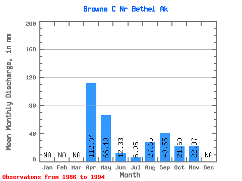
| Statistic | Jan | Feb | Mar | Apr | May | Jun | Jul | Aug | Sep | Oct | Nov | Dec | Annual |
|---|---|---|---|---|---|---|---|---|---|---|---|---|---|
| Mean | 112.10 | 65.98 | 12.27 | 6.05 | 27.67 | 40.56 | 21.70 | 22.47 | |||||
| Standard Deviation | 91.62 | 27.57 | 8.54 | 5.01 | 18.92 | 26.08 | 16.68 | 16.10 | |||||
| Min | 9.47 | 16.53 | 2.91 | 1.08 | 4.05 | 3.49 | 3.67 | 11.09 | |||||
| Max | 221.19 | 107.61 | 29.47 | 17.49 | 65.04 | 80.35 | 50.35 | 33.85 | |||||
| Coefficient of Variation | 0.82 | 0.42 | 0.70 | 0.83 | 0.68 | 0.64 | 0.77 | 0.72 |
 Return to R-Arctic Net Home Page