|
|
|||||||||||||||||
| Point ID: 9333 | Downloads | Plots | Site Data | Code: 15056560 |
|
|
|||||||||||||||||
| Download | |
|---|---|
| Site Descriptor Information | Site Time Series Data |
| Link to all available data | |
| View: | Time Series | All |
| Units: | m3/s |
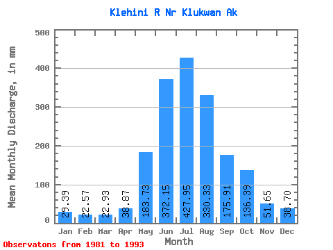
| Statistic | Jan | Feb | Mar | Apr | May | Jun | Jul | Aug | Sep | Oct | Nov | Dec | Annual |
|---|---|---|---|---|---|---|---|---|---|---|---|---|---|
| Mean | 29.39 | 22.76 | 22.93 | 38.87 | 183.70 | 372.15 | 427.89 | 330.28 | 175.91 | 136.37 | 51.65 | 38.69 | 1794.91 |
| Standard Deviation | 7.13 | 4.42 | 7.40 | 13.55 | 63.02 | 76.55 | 85.35 | 57.77 | 62.17 | 58.12 | 24.56 | 14.64 | 254.29 |
| Min | 18.73 | 18.51 | 13.69 | 20.23 | 81.14 | 254.54 | 302.22 | 256.86 | 98.69 | 54.20 | 22.87 | 20.94 | 1337.99 |
| Max | 43.66 | 35.04 | 42.75 | 70.75 | 291.51 | 485.56 | 559.18 | 431.71 | 271.43 | 218.81 | 107.56 | 68.92 | 2170.74 |
| Coefficient of Variation | 0.24 | 0.19 | 0.32 | 0.35 | 0.34 | 0.21 | 0.20 | 0.17 | 0.35 | 0.43 | 0.47 | 0.38 | 0.14 |
 Return to R-Arctic Net Home Page