|
|
|||||||||||||||||
| Point ID: 9331 | Downloads | Plots | Site Data | Code: 15070000 |
|
|
|||||||||||||||||
| Download | |
|---|---|
| Site Descriptor Information | Site Time Series Data |
| Link to all available data | |
| View: | Time Series | All |
| Units: | m3/s |
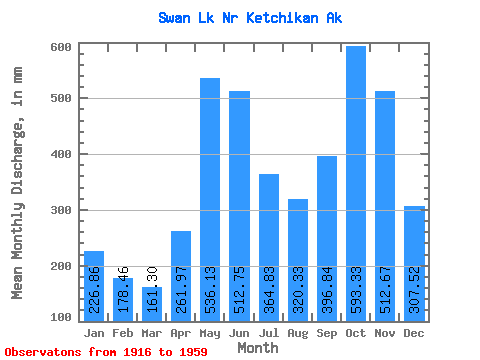
| Statistic | Jan | Feb | Mar | Apr | May | Jun | Jul | Aug | Sep | Oct | Nov | Dec | Annual |
|---|---|---|---|---|---|---|---|---|---|---|---|---|---|
| Mean | 226.83 | 179.99 | 161.26 | 261.96 | 536.06 | 512.74 | 364.77 | 320.29 | 396.83 | 593.25 | 512.67 | 307.49 | 4395.70 |
| Standard Deviation | 166.07 | 137.21 | 91.58 | 106.40 | 114.88 | 112.04 | 110.43 | 147.41 | 175.35 | 208.66 | 252.95 | 198.05 | 528.97 |
| Min | 30.86 | 29.85 | 46.54 | 97.03 | 324.30 | 259.49 | 104.88 | 99.01 | 93.93 | 205.53 | 141.10 | 92.95 | 3140.84 |
| Max | 785.61 | 694.77 | 394.22 | 508.94 | 762.34 | 755.70 | 579.30 | 588.10 | 797.25 | 1101.03 | 1398.04 | 906.34 | 5339.27 |
| Coefficient of Variation | 0.73 | 0.76 | 0.57 | 0.41 | 0.21 | 0.22 | 0.30 | 0.46 | 0.44 | 0.35 | 0.49 | 0.64 | 0.12 |
 Return to R-Arctic Net Home Page