|
|
|||||||||||||||||
| Point ID: 9289 | Downloads | Plots | Site Data | Code: 15081495 |
|
|
|||||||||||||||||
| Download | |
|---|---|
| Site Descriptor Information | Site Time Series Data |
| Link to all available data | |
| View: | Time Series | All |
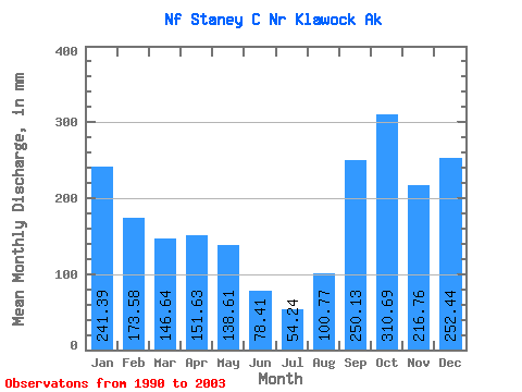
| Units: | m3/s |
| Statistic | Jan | Feb | Mar | Apr | May | Jun | Jul | Aug | Sep | Oct | Nov | Dec | Annual |
|---|---|---|---|---|---|---|---|---|---|---|---|---|---|
| Mean | 241.47 | 174.97 | 146.53 | 151.71 | 138.53 | 78.25 | 54.06 | 100.76 | 250.15 | 310.70 | 216.71 | 252.55 | 2130.80 |
| Standard Deviation | 114.73 | 113.84 | 70.31 | 62.01 | 73.64 | 42.40 | 27.83 | 62.42 | 111.18 | 115.84 | 87.46 | 121.46 | 483.20 |
| Min | 110.46 | 59.07 | 47.30 | 69.82 | 36.73 | 14.59 | 13.72 | 17.08 | 95.42 | 141.42 | 118.79 | 109.26 | 1428.46 |
| Max | 463.26 | 446.60 | 332.61 | 272.46 | 320.15 | 192.67 | 111.81 | 235.31 | 458.14 | 579.34 | 369.07 | 465.87 | 2902.56 |
| Coefficient of Variation | 0.47 | 0.65 | 0.48 | 0.41 | 0.53 | 0.54 | 0.52 | 0.62 | 0.44 | 0.37 | 0.40 | 0.48 | 0.23 |
 Return to R-Arctic Net Home Page