|
|
|||||||||||||||||
| Point ID: 9283 | Downloads | Plots | Site Data | Code: 15030000 |
|
|
|||||||||||||||||
| Download | |
|---|---|
| Site Descriptor Information | Site Time Series Data |
| Link to all available data | |
| View: | Time Series | All |
| Units: | m3/s |
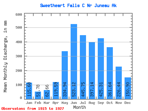
| Statistic | Jan | Feb | Mar | Apr | May | Jun | Jul | Aug | Sep | Oct | Nov | Dec | Annual |
|---|---|---|---|---|---|---|---|---|---|---|---|---|---|
| Mean | 115.68 | 52.22 | 62.65 | 119.59 | 334.88 | 523.13 | 445.70 | 397.08 | 425.31 | 361.59 | 226.44 | 150.88 | 3205.34 |
| Standard Deviation | 129.60 | 30.13 | 54.72 | 82.67 | 75.75 | 88.30 | 90.93 | 101.56 | 120.88 | 82.82 | 87.79 | 98.19 | 283.80 |
| Min | 30.86 | 22.06 | 20.17 | 39.72 | 191.59 | 352.23 | 277.43 | 242.59 | 186.12 | 245.14 | 119.88 | 42.78 | 2830.48 |
| Max | 463.11 | 105.77 | 211.83 | 329.32 | 472.51 | 647.18 | 624.60 | 537.15 | 641.45 | 500.67 | 381.04 | 395.79 | 3798.11 |
| Coefficient of Variation | 1.12 | 0.58 | 0.87 | 0.69 | 0.23 | 0.17 | 0.20 | 0.26 | 0.28 | 0.23 | 0.39 | 0.65 | 0.09 |
 Return to R-Arctic Net Home Page