|
|
|||||||||||||||||
| Point ID: 9276 | Downloads | Plots | Site Data | Code: 15022000 |
|
|
|||||||||||||||||
| Download | |
|---|---|
| Site Descriptor Information | Site Time Series Data |
| Link to all available data | |
| View: | Time Series | All |
| Units: | m3/s |
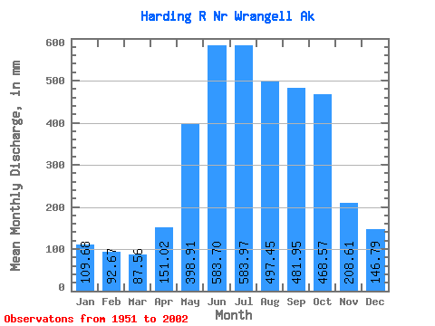
| Statistic | Jan | Feb | Mar | Apr | May | Jun | Jul | Aug | Sep | Oct | Nov | Dec | Annual |
|---|---|---|---|---|---|---|---|---|---|---|---|---|---|
| Mean | 109.66 | 93.47 | 87.56 | 151.02 | 398.85 | 583.71 | 583.88 | 497.38 | 481.95 | 468.50 | 208.61 | 146.77 | 3799.79 |
| Standard Deviation | 76.87 | 61.98 | 47.16 | 54.65 | 82.95 | 90.42 | 107.64 | 129.97 | 145.56 | 162.16 | 100.12 | 91.42 | 410.64 |
| Min | 21.98 | 18.47 | 23.80 | 37.84 | 271.09 | 403.70 | 373.89 | 261.06 | 212.99 | 264.99 | 49.44 | 44.22 | 2888.70 |
| Max | 355.86 | 259.34 | 221.40 | 308.08 | 589.35 | 797.03 | 815.55 | 812.64 | 857.28 | 934.52 | 526.37 | 462.69 | 4881.25 |
| Coefficient of Variation | 0.70 | 0.66 | 0.54 | 0.36 | 0.21 | 0.15 | 0.18 | 0.26 | 0.30 | 0.35 | 0.48 | 0.62 | 0.11 |
 Return to R-Arctic Net Home Page