|
|
|||||||||||||||||
| Point ID: 9271 | Downloads | Plots | Site Data | Code: 15034000 |
|
|
|||||||||||||||||
| Download | |
|---|---|
| Site Descriptor Information | Site Time Series Data |
| Link to all available data | |
| View: | Time Series | All |
| Units: | m3/s |
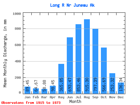
| Statistic | Jan | Feb | Mar | Apr | May | Jun | Jul | Aug | Sep | Oct | Nov | Dec | Annual |
|---|---|---|---|---|---|---|---|---|---|---|---|---|---|
| Mean | 89.42 | 65.22 | 58.86 | 98.45 | 365.79 | 693.47 | 853.35 | 915.16 | 797.39 | 566.60 | 253.32 | 136.32 | 4886.50 |
| Standard Deviation | 62.19 | 51.15 | 35.13 | 50.91 | 130.97 | 181.94 | 179.04 | 212.78 | 234.43 | 192.99 | 127.23 | 88.72 | 741.54 |
| Min | 5.18 | 3.23 | 7.58 | 11.16 | 87.27 | 49.97 | 28.43 | 542.98 | 426.41 | 279.45 | 106.61 | 19.75 | 2163.10 |
| Max | 273.90 | 225.84 | 198.63 | 262.56 | 882.29 | 1125.54 | 1223.29 | 1665.22 | 1665.94 | 1012.24 | 575.44 | 329.78 | 7137.31 |
| Coefficient of Variation | 0.69 | 0.78 | 0.60 | 0.52 | 0.36 | 0.26 | 0.21 | 0.23 | 0.29 | 0.34 | 0.50 | 0.65 | 0.15 |
 Return to R-Arctic Net Home Page