|
|
|||||||||||||||||
| Point ID: 9260 | Downloads | Plots | Site Data | Code: 15049900 |
|
|
|||||||||||||||||
| Download | |
|---|---|
| Site Descriptor Information | Site Time Series Data |
| Link to all available data | |
| View: | Time Series | All |
| Units: | m3/s |
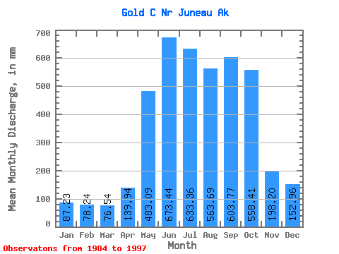
| Statistic | Jan | Feb | Mar | Apr | May | Jun | Jul | Aug | Sep | Oct | Nov | Dec | Annual |
|---|---|---|---|---|---|---|---|---|---|---|---|---|---|
| Mean | 87.17 | 78.92 | 76.54 | 139.97 | 482.97 | 673.47 | 633.24 | 563.62 | 603.81 | 558.34 | 198.15 | 152.98 | 4316.82 |
| Standard Deviation | 65.12 | 45.84 | 57.16 | 58.81 | 123.67 | 163.39 | 203.36 | 254.99 | 282.68 | 247.35 | 146.08 | 131.09 | 868.01 |
| Min | 33.02 | 24.00 | 17.09 | 59.80 | 247.08 | 426.03 | 321.61 | 250.12 | 245.33 | 246.87 | 56.61 | 35.98 | 3034.51 |
| Max | 269.19 | 202.50 | 235.41 | 250.50 | 612.22 | 958.20 | 1125.62 | 1208.97 | 1287.14 | 1049.39 | 535.57 | 460.29 | 6229.63 |
| Coefficient of Variation | 0.75 | 0.58 | 0.75 | 0.42 | 0.26 | 0.24 | 0.32 | 0.45 | 0.47 | 0.44 | 0.74 | 0.86 | 0.20 |
 Return to R-Arctic Net Home Page