|
|
|||||||||||||||||
| Point ID: 9240 | Downloads | Plots | Site Data | Code: 15038000 |
|
|
|||||||||||||||||
| Download | |
|---|---|
| Site Descriptor Information | Site Time Series Data |
| Link to all available data | |
| View: | Time Series | All |
| Units: | m3/s |
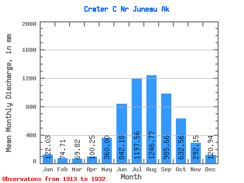
| Statistic | Jan | Feb | Mar | Apr | May | Jun | Jul | Aug | Sep | Oct | Nov | Dec | Annual |
|---|---|---|---|---|---|---|---|---|---|---|---|---|---|
| Mean | 121.97 | 75.36 | 69.85 | 100.22 | 359.98 | 842.16 | 1197.39 | 1246.63 | 985.71 | 632.46 | 292.13 | 120.95 | 5817.57 |
| Standard Deviation | 80.43 | 57.56 | 36.94 | 38.98 | 141.51 | 205.27 | 287.46 | 310.50 | 210.97 | 216.66 | 182.62 | 82.81 | 551.39 |
| Min | 12.70 | 21.02 | 30.86 | 49.76 | 137.09 | 441.54 | 931.22 | 916.88 | 652.54 | 347.04 | 104.92 | 61.45 | 4691.55 |
| Max | 257.08 | 238.65 | 126.87 | 184.03 | 604.35 | 1321.47 | 2133.59 | 2204.91 | 1444.89 | 1189.11 | 638.67 | 375.56 | 6469.23 |
| Coefficient of Variation | 0.66 | 0.76 | 0.53 | 0.39 | 0.39 | 0.24 | 0.24 | 0.25 | 0.21 | 0.34 | 0.62 | 0.69 | 0.10 |
 Return to R-Arctic Net Home Page