|
|
|||||||||||||||||
| Point ID: 9215 | Downloads | Plots | Site Data | Code: 15200280 |
|
|
|||||||||||||||||
| Download | |
|---|---|
| Site Descriptor Information | Site Time Series Data |
| Link to all available data | |
| View: | Time Series | All |
| Units: | m3/s |
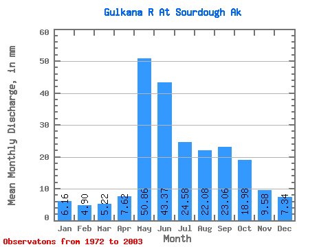
| Statistic | Jan | Feb | Mar | Apr | May | Jun | Jul | Aug | Sep | Oct | Nov | Dec | Annual |
|---|---|---|---|---|---|---|---|---|---|---|---|---|---|
| Mean | 6.16 | 4.94 | 5.21 | 7.62 | 50.85 | 43.37 | 24.57 | 22.08 | 23.06 | 18.98 | 9.58 | 7.34 | 223.73 |
| Standard Deviation | 2.59 | 1.79 | 1.52 | 4.72 | 20.10 | 16.29 | 9.09 | 10.44 | 13.55 | 10.40 | 4.70 | 3.44 | 49.38 |
| Min | 3.31 | 3.01 | 3.31 | 3.63 | 13.83 | 18.41 | 10.54 | 11.81 | 8.08 | 7.23 | 4.59 | 3.44 | 135.65 |
| Max | 13.24 | 10.10 | 9.32 | 21.51 | 93.14 | 79.56 | 44.59 | 46.66 | 68.10 | 42.32 | 21.81 | 16.62 | 310.44 |
| Coefficient of Variation | 0.42 | 0.36 | 0.29 | 0.62 | 0.40 | 0.38 | 0.37 | 0.47 | 0.59 | 0.55 | 0.49 | 0.47 | 0.22 |
 Return to R-Arctic Net Home Page