|
|
|||||||||||||||||
| Point ID: 9179 | Downloads | Plots | Site Data | Code: 15088000 |
|
|
|||||||||||||||||
| Download | |
|---|---|
| Site Descriptor Information | Site Time Series Data |
| Link to all available data | |
| View: | Time Series | All |
| Units: | m3/s |
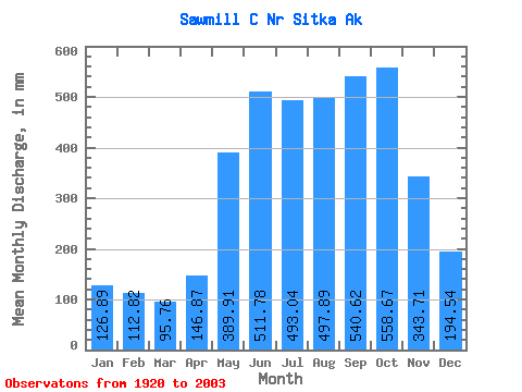
| Statistic | Jan | Feb | Mar | Apr | May | Jun | Jul | Aug | Sep | Oct | Nov | Dec | Annual |
|---|---|---|---|---|---|---|---|---|---|---|---|---|---|
| Mean | 126.88 | 113.78 | 95.76 | 146.87 | 389.84 | 511.79 | 492.97 | 497.83 | 540.62 | 558.59 | 343.70 | 194.52 | 4122.38 |
| Standard Deviation | 79.87 | 91.08 | 64.66 | 88.98 | 144.83 | 182.17 | 151.16 | 169.35 | 169.98 | 176.95 | 162.25 | 150.04 | 724.83 |
| Min | 22.43 | 22.67 | 18.60 | 44.67 | 45.27 | 39.15 | 65.31 | 87.00 | 260.86 | 265.67 | 57.05 | 37.64 | 2599.89 |
| Max | 375.14 | 440.24 | 274.18 | 481.64 | 646.21 | 856.67 | 732.66 | 927.60 | 935.08 | 904.30 | 725.06 | 614.31 | 6113.73 |
| Coefficient of Variation | 0.63 | 0.80 | 0.68 | 0.61 | 0.37 | 0.36 | 0.31 | 0.34 | 0.31 | 0.32 | 0.47 | 0.77 | 0.18 |
 Return to R-Arctic Net Home Page