|
|
|||||||||||||||||
| Point ID: 9174 | Downloads | Plots | Site Data | Code: 15087610 |
|
|
|||||||||||||||||
| Download | |
|---|---|
| Site Descriptor Information | Site Time Series Data |
| Link to all available data | |
| View: | Time Series | All |
| Units: | m3/s |
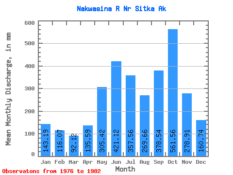
| Statistic | Jan | Feb | Mar | Apr | May | Jun | Jul | Aug | Sep | Oct | Nov | Dec | Annual |
|---|---|---|---|---|---|---|---|---|---|---|---|---|---|
| Mean | 143.17 | 117.06 | 92.11 | 135.58 | 305.37 | 421.13 | 357.51 | 269.63 | 378.54 | 561.47 | 278.90 | 160.72 | 3259.88 |
| Standard Deviation | 118.76 | 82.01 | 42.71 | 63.37 | 54.97 | 89.74 | 73.45 | 57.27 | 90.76 | 188.44 | 97.61 | 74.46 | 224.93 |
| Min | 39.89 | 39.88 | 31.99 | 59.41 | 266.89 | 268.24 | 249.74 | 225.07 | 287.10 | 406.91 | 103.73 | 41.37 | 3031.91 |
| Max | 356.21 | 264.51 | 154.21 | 233.19 | 405.28 | 511.89 | 472.02 | 365.09 | 518.37 | 931.78 | 376.35 | 247.08 | 3518.26 |
| Coefficient of Variation | 0.83 | 0.70 | 0.46 | 0.47 | 0.18 | 0.21 | 0.20 | 0.21 | 0.24 | 0.34 | 0.35 | 0.46 | 0.07 |
 Return to R-Arctic Net Home Page