|
|
|||||||||||||||||
| Point ID: 9172 | Downloads | Plots | Site Data | Code: 15087570 |
|
|
|||||||||||||||||
| Download | |
|---|---|
| Site Descriptor Information | Site Time Series Data |
| Link to all available data | |
| View: | Time Series | All |
| Units: | m3/s |
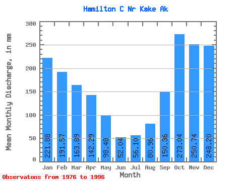
| Statistic | Jan | Feb | Mar | Apr | May | Jun | Jul | Aug | Sep | Oct | Nov | Dec | Annual |
|---|---|---|---|---|---|---|---|---|---|---|---|---|---|
| Mean | 221.84 | 193.21 | 163.87 | 142.29 | 98.46 | 52.04 | 56.09 | 80.95 | 150.36 | 273.00 | 250.74 | 248.16 | 1933.25 |
| Standard Deviation | 133.95 | 154.11 | 96.79 | 83.64 | 62.86 | 24.80 | 34.94 | 63.05 | 91.25 | 101.28 | 107.90 | 165.93 | 422.38 |
| Min | 19.83 | 27.65 | 49.11 | 19.15 | 26.80 | 11.21 | 9.64 | 9.00 | 41.15 | 133.98 | 81.61 | 22.04 | 1205.66 |
| Max | 465.62 | 534.97 | 343.85 | 320.22 | 266.22 | 87.51 | 124.59 | 227.06 | 380.99 | 542.79 | 497.25 | 766.63 | 2734.82 |
| Coefficient of Variation | 0.60 | 0.80 | 0.59 | 0.59 | 0.64 | 0.48 | 0.62 | 0.78 | 0.61 | 0.37 | 0.43 | 0.67 | 0.22 |
 Return to R-Arctic Net Home Page