|
|
|||||||||||||||||
| Point ID: 9155 | Downloads | Plots | Site Data | Code: 15107000 |
|
|
|||||||||||||||||
| Download | |
|---|---|
| Site Descriptor Information | Site Time Series Data |
| Link to all available data | |
| View: | Time Series | All |
| Units: | m3/s |
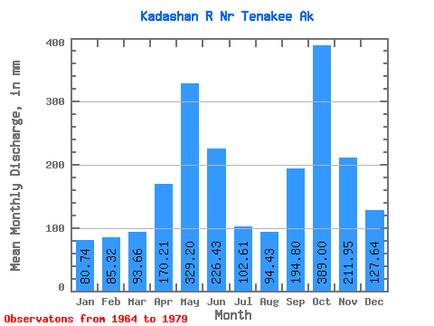
| Statistic | Jan | Feb | Mar | Apr | May | Jun | Jul | Aug | Sep | Oct | Nov | Dec | Annual |
|---|---|---|---|---|---|---|---|---|---|---|---|---|---|
| Mean | 80.72 | 86.05 | 93.66 | 170.22 | 329.15 | 226.42 | 102.59 | 94.42 | 194.79 | 388.94 | 211.95 | 127.62 | 2141.00 |
| Standard Deviation | 54.49 | 73.53 | 49.97 | 63.41 | 89.88 | 90.68 | 40.19 | 50.52 | 93.03 | 176.25 | 100.28 | 62.28 | 219.29 |
| Min | 15.29 | 15.35 | 28.95 | 76.00 | 173.94 | 88.11 | 37.51 | 29.80 | 51.71 | 146.90 | 43.42 | 26.77 | 1772.96 |
| Max | 199.00 | 256.88 | 207.75 | 281.23 | 521.70 | 366.13 | 166.61 | 179.53 | 392.76 | 745.39 | 387.77 | 213.04 | 2594.05 |
| Coefficient of Variation | 0.68 | 0.85 | 0.53 | 0.37 | 0.27 | 0.40 | 0.39 | 0.54 | 0.48 | 0.45 | 0.47 | 0.49 | 0.10 |
 Return to R-Arctic Net Home Page