|
|
|||||||||||||||||
| Point ID: 9150 | Downloads | Plots | Site Data | Code: 15108000 |
|
|
|||||||||||||||||
| Download | |
|---|---|
| Site Descriptor Information | Site Time Series Data |
| Link to all available data | |
| View: | Time Series | All |
| Units: | m3/s |
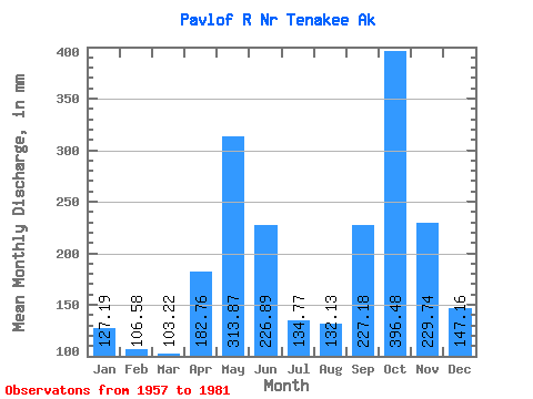
| Statistic | Jan | Feb | Mar | Apr | May | Jun | Jul | Aug | Sep | Oct | Nov | Dec | Annual |
|---|---|---|---|---|---|---|---|---|---|---|---|---|---|
| Mean | 127.16 | 107.51 | 103.20 | 182.76 | 313.82 | 226.88 | 134.76 | 132.13 | 227.19 | 396.43 | 229.73 | 147.15 | 2334.42 |
| Standard Deviation | 106.72 | 76.00 | 46.91 | 63.97 | 94.43 | 77.05 | 36.83 | 70.11 | 98.44 | 177.32 | 100.46 | 91.93 | 272.60 |
| Min | 18.49 | 15.75 | 25.32 | 68.77 | 135.61 | 87.20 | 66.25 | 44.38 | 66.75 | 138.10 | 39.95 | 29.28 | 1724.62 |
| Max | 472.67 | 301.41 | 224.75 | 307.36 | 568.81 | 413.35 | 197.12 | 304.51 | 435.18 | 937.49 | 495.07 | 317.46 | 2769.68 |
| Coefficient of Variation | 0.84 | 0.71 | 0.46 | 0.35 | 0.30 | 0.34 | 0.27 | 0.53 | 0.43 | 0.45 | 0.44 | 0.62 | 0.12 |
 Return to R-Arctic Net Home Page