|
|
|||||||||||||||||
| Point ID: 9148 | Downloads | Plots | Site Data | Code: 15106960 |
|
|
|||||||||||||||||
| Download | |
|---|---|
| Site Descriptor Information | Site Time Series Data |
| Link to all available data | |
| View: | Time Series | All |
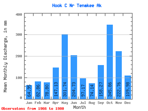
| Units: | m3/s |
| Statistic | Jan | Feb | Mar | Apr | May | Jun | Jul | Aug | Sep | Oct | Nov | Dec | Annual |
|---|---|---|---|---|---|---|---|---|---|---|---|---|---|
| Mean | 64.95 | 83.53 | 78.78 | 147.15 | 301.65 | 204.78 | 97.19 | 74.17 | 158.26 | 345.81 | 222.75 | 110.01 | 1903.19 |
| Standard Deviation | 38.89 | 75.43 | 46.48 | 62.26 | 82.19 | 92.98 | 40.58 | 36.04 | 74.41 | 190.07 | 122.80 | 70.35 | 305.45 |
| Min | 17.77 | 11.84 | 27.46 | 39.74 | 151.26 | 84.38 | 31.83 | 26.59 | 78.34 | 108.96 | 41.41 | 33.02 | 1510.73 |
| Max | 146.42 | 268.94 | 180.22 | 266.76 | 451.07 | 371.36 | 172.71 | 144.88 | 343.70 | 780.17 | 426.21 | 229.14 | 2489.75 |
| Coefficient of Variation | 0.60 | 0.90 | 0.59 | 0.42 | 0.27 | 0.45 | 0.42 | 0.49 | 0.47 | 0.55 | 0.55 | 0.64 | 0.16 |
 Return to R-Arctic Net Home Page