|
|
|||||||||||||||||
| Point ID: 91 | Downloads | Plots | Site Data | Code: 05AD012 |
|
|
|||||||||||||||||
| Download | |
|---|---|
| Site Descriptor Information | Site Time Series Data |
| Link to all available data | |
| View: | Time Series | All |
| Units: | m3/s |
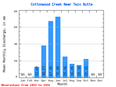
| Statistic | Jan | Feb | Mar | Apr | May | Jun | Jul | Aug | Sep | Oct | Nov | Dec | Annual |
|---|---|---|---|---|---|---|---|---|---|---|---|---|---|
| Mean | 12.72 | 38.27 | 67.34 | 72.39 | 25.07 | 16.47 | 15.17 | 22.31 | |||||
| Standard Deviation | 17.44 | 13.45 | 58.57 | 59.92 | 30.51 | 12.19 | 12.15 | 21.80 | |||||
| Min | 1.80 | 19.55 | 9.40 | 12.51 | 5.72 | 5.33 | 5.91 | 8.14 | |||||
| Max | 51.13 | 49.41 | 184.01 | 190.99 | 89.27 | 36.41 | 43.20 | 74.62 | |||||
| Coefficient of Variation | 1.37 | 0.35 | 0.87 | 0.83 | 1.22 | 0.74 | 0.80 | 0.98 |
 Return to R-Arctic Net Home Page