|
|
|||||||||||||||||
| Point ID: 9090 | Downloads | Plots | Site Data | Code: 15908000 |
|
|
|||||||||||||||||
| Download | |
|---|---|
| Site Descriptor Information | Site Time Series Data |
| Link to all available data | |
| View: | Time Series | All |
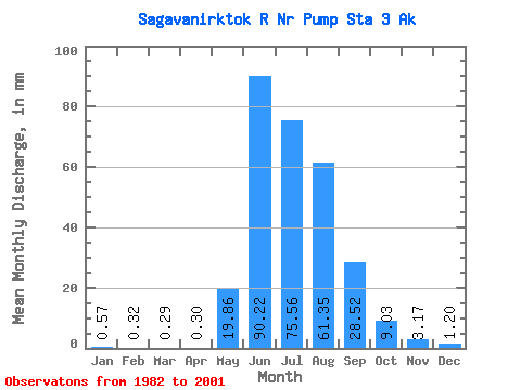
| Units: | m3/s |
| Statistic | Jan | Feb | Mar | Apr | May | Jun | Jul | Aug | Sep | Oct | Nov | Dec | Annual |
|---|---|---|---|---|---|---|---|---|---|---|---|---|---|
| Mean | 0.57 | 0.32 | 0.29 | 0.30 | 19.86 | 90.22 | 75.55 | 61.34 | 28.52 | 9.03 | 3.17 | 1.20 | 291.07 |
| Standard Deviation | 0.77 | 0.60 | 0.57 | 0.51 | 18.70 | 25.82 | 20.40 | 19.45 | 11.29 | 3.78 | 1.45 | 0.92 | 64.76 |
| Min | 0.00 | 0.00 | 0.00 | 0.00 | 0.07 | 59.04 | 44.70 | 29.87 | 13.45 | 4.40 | 1.16 | 0.06 | 183.59 |
| Max | 2.84 | 2.15 | 2.01 | 1.78 | 56.47 | 148.36 | 116.01 | 98.42 | 60.70 | 18.45 | 5.46 | 3.67 | 393.43 |
| Coefficient of Variation | 1.36 | 1.87 | 1.98 | 1.69 | 0.94 | 0.29 | 0.27 | 0.32 | 0.40 | 0.42 | 0.46 | 0.77 | 0.22 |
 Return to R-Arctic Net Home Page