|
|
|||||||||||||||||
| Point ID: 9079 | Downloads | Plots | Site Data | Code: 49148 |
|
|
|||||||||||||||||
| Download | |
|---|---|
| Site Descriptor Information | Site Time Series Data |
| Link to all available data | |
| View: | Time Series | All |
| Units: | m3/s |
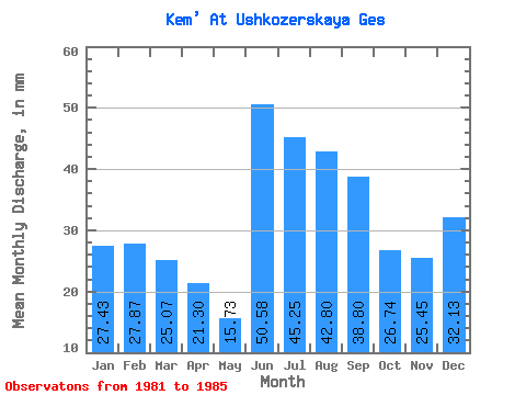
| Statistic | Jan | Feb | Mar | Apr | May | Jun | Jul | Aug | Sep | Oct | Nov | Dec | Annual |
|---|---|---|---|---|---|---|---|---|---|---|---|---|---|
| Mean | 27.43 | 28.11 | 25.06 | 21.30 | 15.72 | 50.58 | 45.24 | 42.80 | 38.80 | 26.73 | 25.45 | 32.13 | 379.68 |
| Standard Deviation | 11.98 | 10.24 | 10.25 | 7.14 | 15.46 | 27.96 | 13.64 | 4.89 | 5.79 | 17.53 | 7.74 | 10.66 | 38.34 |
| Min | 10.56 | 11.68 | 10.14 | 10.92 | 0.18 | 15.58 | 30.68 | 35.88 | 33.97 | 9.13 | 15.35 | 24.10 | 318.79 |
| Max | 43.68 | 38.38 | 38.48 | 30.95 | 32.76 | 79.77 | 62.92 | 49.66 | 48.57 | 56.16 | 36.99 | 49.92 | 413.06 |
| Coefficient of Variation | 0.44 | 0.36 | 0.41 | 0.34 | 0.98 | 0.55 | 0.30 | 0.11 | 0.15 | 0.66 | 0.30 | 0.33 | 0.10 |
 Return to R-Arctic Net Home Page