|
|
|||||||||||||||||
| Point ID: 9074 | Downloads | Plots | Site Data | Code: 49119 |
|
|
|||||||||||||||||
| Download | |
|---|---|
| Site Descriptor Information | Site Time Series Data |
| Link to all available data | |
| View: | Time Series | All |
| Units: | m3/s |
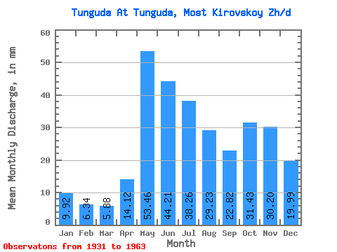
| Statistic | Jan | Feb | Mar | Apr | May | Jun | Jul | Aug | Sep | Oct | Nov | Dec | Annual |
|---|---|---|---|---|---|---|---|---|---|---|---|---|---|
| Mean | 9.92 | 6.40 | 5.88 | 14.12 | 53.45 | 44.21 | 38.25 | 29.22 | 22.82 | 31.43 | 30.20 | 19.98 | 303.24 |
| Standard Deviation | 6.27 | 4.21 | 4.11 | 12.26 | 17.83 | 16.80 | 23.27 | 18.11 | 12.39 | 16.75 | 15.08 | 9.40 | 116.50 |
| Min | 1.74 | 1.15 | 1.04 | 1.04 | 17.95 | 10.15 | 10.24 | 10.01 | 6.39 | 6.83 | 2.41 | 2.12 | 131.30 |
| Max | 20.01 | 12.48 | 12.55 | 46.43 | 75.78 | 62.24 | 103.44 | 64.89 | 43.72 | 57.24 | 51.84 | 33.55 | 518.53 |
| Coefficient of Variation | 0.63 | 0.66 | 0.70 | 0.87 | 0.33 | 0.38 | 0.61 | 0.62 | 0.54 | 0.53 | 0.50 | 0.47 | 0.38 |
 Return to R-Arctic Net Home Page