|
|
|||||||||||||||||
| Point ID: 9072 | Downloads | Plots | Site Data | Code: 49108 |
|
|
|||||||||||||||||
| Download | |
|---|---|
| Site Descriptor Information | Site Time Series Data |
| Link to all available data | |
| View: | Time Series | All |
| Units: | m3/s |
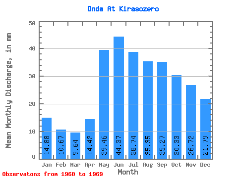
| Statistic | Jan | Feb | Mar | Apr | May | Jun | Jul | Aug | Sep | Oct | Nov | Dec | Annual |
|---|---|---|---|---|---|---|---|---|---|---|---|---|---|
| Mean | 14.88 | 10.77 | 9.64 | 14.42 | 39.45 | 44.37 | 38.74 | 35.34 | 35.27 | 30.33 | 26.72 | 21.79 | 325.19 |
| Standard Deviation | 11.50 | 8.63 | 4.73 | 8.54 | 15.84 | 17.65 | 15.77 | 16.50 | 16.98 | 17.48 | 15.82 | 14.30 | 134.14 |
| Min | 3.56 | 3.18 | 3.48 | 4.59 | 4.91 | 12.49 | 16.79 | 17.32 | 14.12 | 6.94 | 6.56 | 6.21 | 107.27 |
| Max | 36.59 | 29.31 | 16.97 | 30.71 | 57.27 | 76.73 | 73.00 | 75.48 | 73.65 | 66.55 | 56.97 | 47.46 | 596.13 |
| Coefficient of Variation | 0.77 | 0.80 | 0.49 | 0.59 | 0.40 | 0.40 | 0.41 | 0.47 | 0.48 | 0.58 | 0.59 | 0.66 | 0.41 |
 Return to R-Arctic Net Home Page